State parks book utilizes drone photography
November 20-26, 2017
“Dedicated to those who dream of flying
and viewing our earth from different perspectives.”
~ Tim Donar, Arkansas State Parks
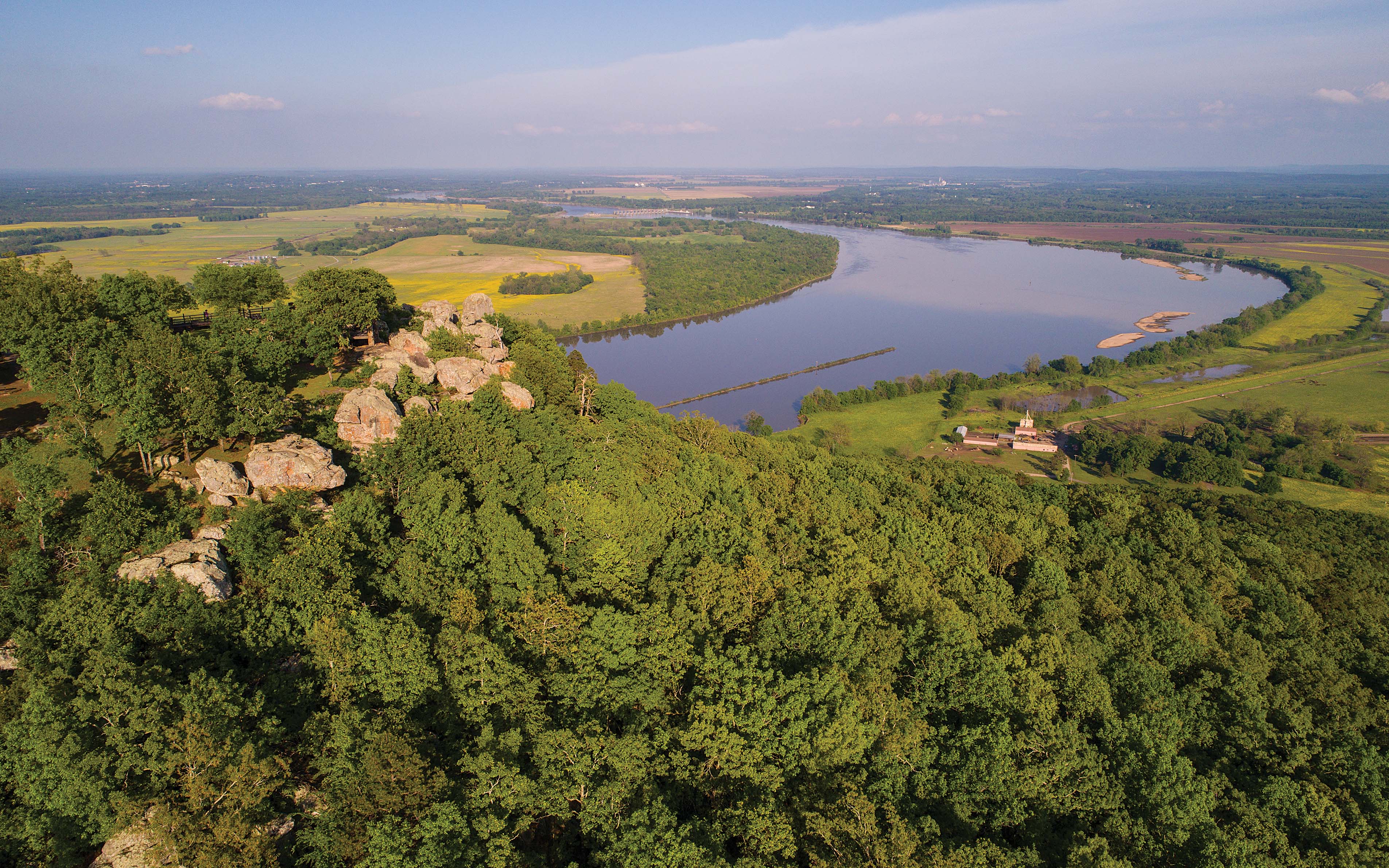
By Jay Edwards
In the foreword to the new book “Arkansas State Parks” by Tim Donar, Grady Spann, director of Arkansas Parks and Tourism writes, “Within this book, you will find the talents of Tim Donar’s aerial photography. I am pleased with the results and how his photography has brought a new perspective of our Arkansas State Parks.”
Tim Donar grew up surrounded by the beauty of Northern California where he enjoyed hobbies like building and flying electronic model airplanes and then later, photography. Combining the two, one day he mounted a 35mm on one of his balsa planes. “With those, you never knew what you were going to get,” he says, “because the camera sits outside and is pointed at an angle to the wing. So I never knew what I was getting and would have to rush off to get the film developed to find out.”
But he says it worked pretty well and there were good opportunities to fly as the model airplane club he was in obtained permission from the Air Force to fly on one of the nearby bases. “We’d go to the gate, show our driver’s license and they would let us go back to one of the helicopter pads. So that was kind of the beginning of this for me. I got to photograph an air show like the ones they have at the Little Rock Air Force Base; and I also shot landmarks like Anaheim Stadium, where the Angels play.”
Aerial photography has changed a great deal since those days, with the arrival of digital photos and drones.
“Back then,” Donar says, “you had to have a runway for the planes. Today a drone can take off from almost any spot, like the board walk at the Louisiana Purchase State Park, for instance. And now you can see everything in real time so you know what you want to shoot; plus you’re able to frame the shots and adjust the camera settings.”
Donar moved from California to Conway in 1992 to take a job with Acxiom. He still lives there and now works for Hewlett Packard.
“I used to visit places like Petit Jean, Pinnacle Mountain and the Plantation Museum. I was into photography, and also drones, which got me thinking that it would be pretty neat to start photographing some of the parks. Then I thought, well, if I do a few I might as well do them all.”
Upon further investigation, he learned that nothing like this had been done. Thus, he set out on a quest to capture some of the state’s most beautiful and interesting places from above.
Donar knew about the ban on drones in national parks, implemented in August of 2014 after a man visiting Yellowstone flew his drone over the Grand Prismatic Spring to get some photos. That ended badly, when the drone crashed into the Spring’s rich, blue water.
“There were also incidents of people chasing the animals with their drones,” Donar said. Incidences like those at Yellowstone and similar ones in other parks sealed the fate of drone photography in national parks.
Donar hoped Arkansas might be more lenient and contacted Spann with his idea. If you want to take photos of the state parks in Arkansas for commercial use, you need a permit from Arkansas Parks and Tourism. They run about $500. Donar was the first to ask about getting a permit to fly his drone in all the state parks.
“A project like this had never been proposed and the cost would be $25,000,” he says. “There were many discussions about my idea before they allowed me to move forward.”
This past April, after getting the green light from Spann, Donar became an Arkansas traveler of sorts, usually heading out on a Friday after work and searching for a place to stay near the park he would be shooting that weekend.
Looking at the same app used by Fedex and UPS drivers, Donar discovered that if you drive to all the state parks in one continuous loop, the shortest route to reach all 52 of them is 2,600 miles. He logged many more than that, at times returning as many as three times to one park to get the shot he wanted. In the book he has included a map showing the locations of all the parks, which run from one corner of the state to another, along with GPS coordinates.
One of Donar’s goals for the book was that every photo would be shot from his drone – “They are all aerial photos, ranging from about ten feet off the ground all the way to 300 feet. It gives you a different perspective of the parks.”
He took over 7,000 photos, from which he chose 305 for his book. His last trip was a return to Hampson Archeological Museum in Mississippi County. The visitor center and museum wasn’t finished when he had visited the first time but he called a week before his book was scheduled for printing and they told him the landscaping had just gone in, so he jumped in his car for the two hour drive to northeast Arkansas.
Another time he was headed back to Lake DeGray because his previous trip was washed out with thunderstorms. He got to Arkadelphia and checked into the familiar Hampton Inn. The next morning at 5:00 a.m., he arose to a thick fog. “It didn’t look good but I drove to the park hoping for the best,” he remembers. “By the time I got there, the fog was thinning and the sun was breaking through and it turned into one of my favorite shots.”
It was so good in fact that he chose it for the cover.
“Arkansas’s State Parks are special places,” Director Spann writes in his Forward. “Families have been making memories with us since 1923 when the park system was first authorized, and now over 8 million guests per year enjoy historical, cultural, recreational and natural parks. Our parks offer so many unique experiences to our guests. You can walk on the same grounds where American Indians lived thousands of years ago at Parkin and Toltec Mounds Archeological State Parks, and you can hike a trail at Petit Jean State Park that was built by the Civilian Conservation Corps in the 1930s. You can call and listen for the response of owls during an interpretive program at Village Creek State Park, whitewater kayak on a National Wild & Scenic River at Cossatot, and ride the contours of the Ozark landscape on the Hidden Diversity Trail at Hobbs State Park-Conservation Area. Or consider finding a quiet spot among the cypress trees of America’s largest oxbow lake—where you might just land the catch of the day—at Lake Chicot State Park. It is my hope that the images captured in this book inspire you to visit and gain a different perspective at an Arkansas State Park.”
“So many of the visitors to our state parks are from other parts of the country,” Donar says. “I wanted them, if they were only at one of the parks, to have something to be able to take back with them as a keepsake, as a reminder of their trip.”
If, as Donar hopes, those travelers do purchase the book, it will also likely remind them why they want to come back.
Arkansas State Parks by Tim Donar is available for $29.95 at any Bedford Camera location as well as any Arkansas State Park visitor center. Or you can order a copy at https://www.upn7.com/.